Why a River Is More Than a Line on a Map
River channel changes can reshape bends, banks and paths. Learn how to read the signs, compare maps with the ground and make safer riverside decisions.
The common mistake is to treat the blue line on a map as a river’s permanent address. River channel changes can leave a walker facing a cut-off bend or a landowner wondering why water has spread across a familiar patch of floodplain. A map records a chosen moment and scale; it does not promise the water will keep the same course.
The channel is the route the river occupies at a particular time. The valley is the wider space through which it can shift, including low ground that may carry water during floods. Keeping those two features distinct makes it easier to read a map, understand riverside clues and decide when to seek local advice.
What signs suggest a river channel is changing?
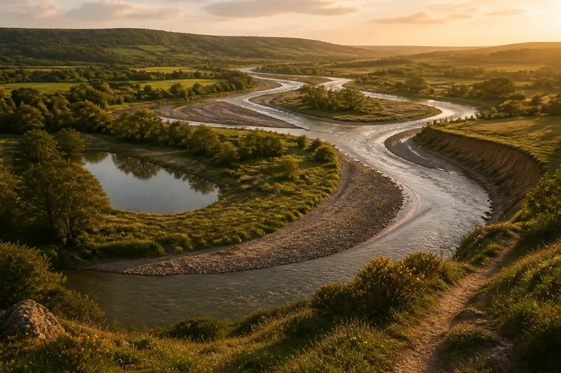
On a bend, flowing water tends to erode the outer bank and deposit some of its load along the inner bank. Over time, a bend may grow more pronounced, migrate across the valley floor or be bypassed by a shorter route during a flood. The old curve can remain as a crescent-shaped pool or damp hollow after the main flow has moved away.
Other rivers split into branches around gravel bars or islands, then change which branches carry the most water. A stream may also shift sideways after debris, bank collapse or repeated high flows alter its route. These are different kinds of channel adjustment, not signs that every river moves in the same way.
Look for several clues together: a fresh bare bank, exposed roots, a new deposit of sand or gravel, or a curved damp hollow beside the current channel. Each can have more than one explanation. Like a loose thread in a piece of fabric, a single clue shows where something may be changing without explaining the whole pattern.
What should you do in different riverside situations?
If you are walking beside the river, what should you watch for?
Use the river as a changing feature, not as a dependable boundary. Stay on a maintained path and follow signs, barriers and local notices. A bank that looks firm from the path may be undercut or soft, especially after high water.
Say you return to a riverside footpath and see fresh gravel beside a bend and a muddy hollow beyond it. Stay on the marked route and observe from stable ground rather than stepping across the deposit. The clues suggest recent water activity, but they do not establish that the bank is safe to approach.
If you are reading a map, which source should you trust?
Use the mapped channel to orient yourself, then compare it with the ground. A paper map, online base map and current aerial image may differ because they show different dates, scales or levels of detail. For a walk, confirm your route with current waymarks and local notices rather than assuming one source must be wrong.
Near a crossing, treat a bridge or marked path as a more useful reference than a shifting bank or small island. If a property boundary or formal decision depends on the river’s position, a map may not settle the legal line; seek appropriate local professional advice.
If you manage land beside water, what should you record?
Consider whether land lies on the active floodplain, rather than looking only at the channel’s current position. Low terraces, old meander scars and damp hollows can indicate places water has occupied or reached before. They cannot predict the river’s next route, but they help explain why the river edge may be more changeable than nearby higher ground.
Record where fresh sediment appears, which bank seems to be retreating, where water spreads after heavy rain and whether access becomes difficult. If a boundary, building or bank intervention depends on the river’s behaviour, consult the relevant land, planning or water-management professional. The decision should reflect the site and applicable local requirements.
If the river has several branches, what should you notice?
Read the whole gravel bed as part of the channel, not just the branch carrying the most water during your visit. Sediment can build up or be swept away, shifting flow between branches. A dry-looking strip may be inundated later, while an active branch may become a shallow pool or vegetation-covered bar.
Notice where branches connect and where gravel bars divide them. Do not assume a dry branch is a safe route across: loose material and changing flow make apparent gaps part of the river system.
Why can a river move without leaving its valley?
A valley sets the broad corridor available to a river, shaped by its slopes and underlying materials. Within it, water carries sediment, erodes banks and deposits material where its energy falls. Floods can make these processes more visible by spreading flow across low ground and opening or reconnecting channels.
Vegetation, debris and sediment also affect the route. Roots can bind some banks, while bare or saturated ground may be more easily worn away. A fallen tree can redirect flow locally; a gravel deposit can divide it. These influences interact, so a change in one place may alter where water presses or settles nearby.
Not every apparent shift lasts. A seasonal channel may carry water only in wetter conditions, and a flood may leave debris or sediment that changes the river’s appearance without permanently moving its main course. Comparing observations made in different conditions can help distinguish a temporary change from a more established route.
What questions do people ask about river channel changes?
Does a river always change its course?
No. Some channels remain comparatively stable for long periods, while others shift more readily because of their shape, flow, sediment and banks. Treat the current channel as useful information, not a permanent line.
Can an old river bend remain after the water moves?
Yes. A cut-off bend may persist as a curved wetland, pond or damp depression alongside the active channel. It can change as sediment accumulates, vegetation grows or high water reconnects it with the river.
Why does a mapped river seem to be in the wrong place?
The map may be accurate for its source date and intended scale, while the river has since shifted or the map has simplified a complex reach. Check current route information and local conditions wherever a small difference in position matters.
Can a river shift outside its valley?
Ordinarily, the valley constrains the river’s broad route, although water can spread beyond the channel across its floodplain. Major changes to the landscape can alter the wider course, which is different from routine movement within a valley.
How can you turn river clues into a practical decision?
For a walk, follow current signs and a sound path. For map reading, treat the channel line as a snapshot and confirm the route on the ground. For a land decision, look beyond the bank to the valley floor and get professional advice when the consequences matter.
- If a path is marked open and its surface is firm, stay on it; if it is closed, damaged or soft, choose another route and follow local notices.
- If fresh gravel lies beside the channel, observe from stable ground; if reaching it would mean crossing loose material, stay back and use a safer viewpoint.
- If roots are newly exposed on a bank, keep clear of the edge; if the path runs close to the damaged section, follow a diversion or turn back.
- If a map and current waymarks agree at a crossing, use the marked route; if they conflict, follow current local instructions and do not improvise a crossing.
- If a damp hollow or old bend lies in a field, record its position and condition; if a land decision depends on its flood history, ask a suitable local water or land professional.
- If several channels divide a gravel bed, observe their connections from a safe path; if a branch is dry, do not treat it as a dependable crossing.
Imagine a walker sees a new gravel bar beside a bend, while the footpath ahead is signed open but its edge looks soft. The walker stays on the firm marked path, notes the altered channel from a stable viewpoint and avoids the bar. If the path itself appears damaged or a notice closes it, the walker turns back and takes a signed alternative. The decision is to observe the change without treating a new landform as either a safe shortcut or proof of a lasting river shift.
River channel changes make more sense when you read the whole setting: the banks, deposits, old bends, floodplain and route information together. A fresh gravel bar or wet hollow is a clue to consider alongside the others, not a reason to approach an unstable edge. That habit helps you understand what the river is doing now while leaving room for its next change.